Esri Features WAFWA for Conservation Efforts Across North America

Find about how we were featured in Esri for our latest conservation efforts across North America.
Open Data Site Supports Fish, Wildlife Conservation Efforts in North America
State fish and wildlife personnel from across the western United States are working together to save priority species and their habitats, and many of them are connected with the Western Association of Fish and Wildlife Agencies (WAFWA). A nonprofit organization, WAFWA coordinates with agencies from 19 US states and 5 Canadian provinces over 3.7 million square miles of some of North America’s most wild and scenic country to ensure strategic, science-based conservation and practical resource management.
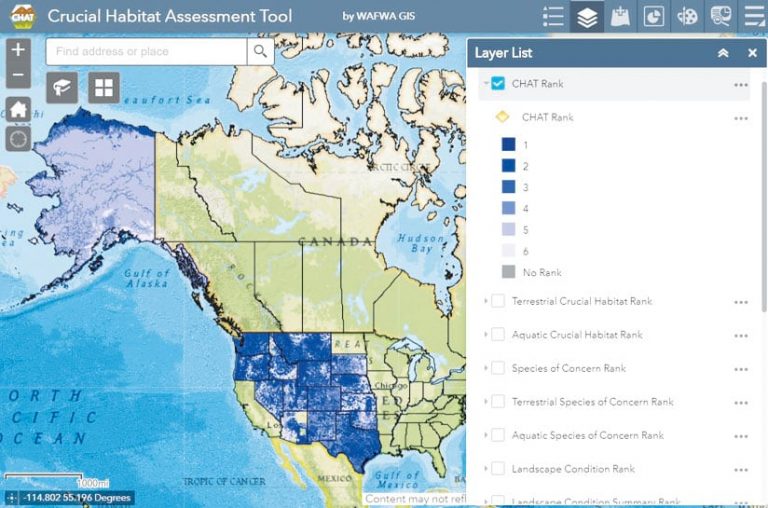
The organization shares data using an online land-use planning solution called the Crucial Habitat Assessment Tool (CHAT). Recently, WAFWA leaders decided to upgrade CHAT to an open data website so it would be easier to customize, control content, and collect and share information.

“We needed a technological solution to help our conservation work reach new heights—one that allows us to grow the site and add new features,”
said Mike Houts, GIS lead for WAFWA-CHAT and a research associate for the Kansas Biological Survey at the University of Kansas.
An Upgrade Facilitates Growth
CHAT, a nonregulatory tool originally created by the Western Governors’ Association, uses the best available data to rank each area in the region with regard to wildlife habitat conservation and how well state policies support that. The CHAT website was initially created by a third-party company that employed an online map service to display relevant data.
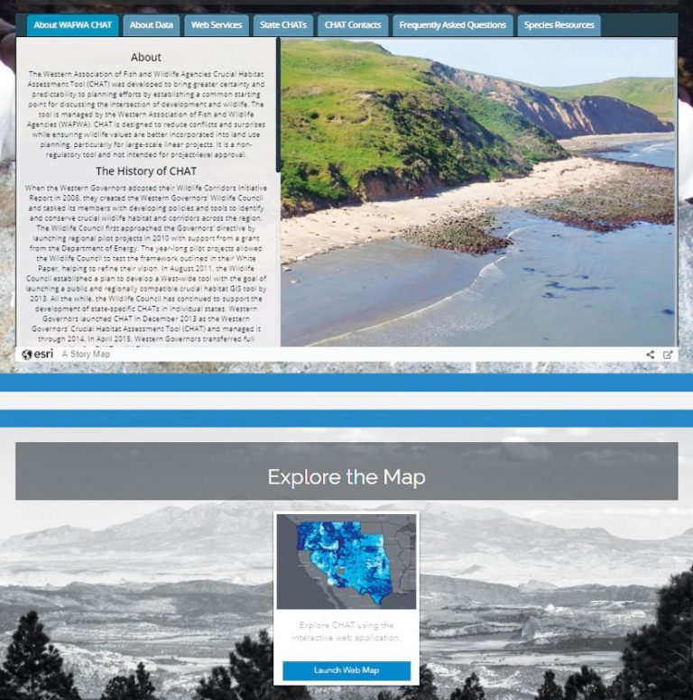
To upgrade CHAT so it could be managed internally, Houts and the GIS team elected to use ArcGIS Online and ArcGIS Hub. They took advantage of the ArcGIS Online cloud-based mapping capabilities to create and share maps and data. Then they used ArcGIS Hub to share open data on WAFWA’s hub site with the goal of engaging governments and communities around related policy initiatives.
“Over the course of the last year, we really started digging into ArcGIS Online and ArcGIS Hub, and that’s turned out to be incredibly beneficial,”
said Houts
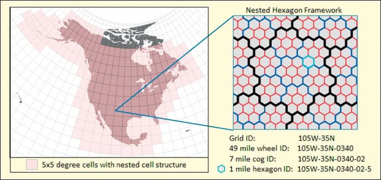
The use of CHAT data and maps is quickly growing based on the needs of specific projects and initiatives. To facilitate the expansion of CHAT to states beyond the western United States and address data and location privacy concerns, the University of Kansas developed the Nested Hexagon Framework (NHF). Covering all of North America, the NHF consists of three nested spatial mapping units and a standardized set of attributes—such as species name and observation date—to summarize integrated datasets and convey information. By relating the attribute data to a hexagonal/cog/wheel spatial mapping unit (which is somewhat analogous to the Public Land Survey System’s township/range/section mapping unit used in the United States), the NHF allows various agencies to share their information without revealing raw data, such as sensitive spatial data or precise locations. This has proven valuable for states with stringent privacy laws. States can then use the datasets summarized by the NHF to determine CHAT ranks.

Improved Control
The CHAT GIS team selected ArcGIS Hub because of its high usability. Houts said the site’s primary web page and the secondary topic-specific pages are now easier to design and implement. Overall website management has also been simplified. When creating a new hub page to summarize a WAFWA project, for example, project leaders can easily convert a Microsoft PowerPoint presentation that highlights goals and content into a story map that can then be posted on the hub page.
“Now we’ve got improved control over these sites and can add new projects and new text,” said Houts. “Our team can update things really easily, as opposed to going through our third-party vendor.”
Because ArcGIS Hub enables open data sharing and better data management, WAFWA can efficiently share data with people from state agencies who visit the site. This is a huge development, given that, as Houts noted, the details in CHAT data were not openly shared before. Harnessing this momentum, WAFWA and state agencies are now working to leverage the CHAT and the NHF to make more information available for use in decision-making processes.
Visitors to WAFWA’s hub site can download CHAT attribute data for the entire western United States as a .dbf file, and the NHF spatial grid is available for download in 5 x 5 degree tiles. Users simply download each piece and join them by the hexagon ID to get the information for their area of interest. Splitting the data up like this makes the downloads smaller and more focused. The GIS team also created a dashboard that logs the number of downloads and what areas are downloaded to help keep track of areas of high interest. The only requirement to obtain data is a valid email address.
Making Data More Accessible
States participating in WAFWA’s CHAT update their habitat priority rankings as needed, and efforts are now under way to launch a mechanism through which dataset owners can submit their data for integration into the NHF. Once this data is summarized and incorporated into the framework, CHAT users will be able to see additional details about what is within each cell.
“The goal of collecting all this data is to help make better decisions and inform, but it doesn’t do any good if the information is not made accessible,” said Houts. “So CHAT, the NHF, and ArcGIS Hub are helping make our data accessible to decision-makers and the public while protecting the raw data.”
WAFWA partners and the public can also use ArcGIS Hub capabilities to provide input on how the CHAT tool is working and what new functionalities they may want to see in the future via a feedback option on the web page.
“The ArcGIS platform and ArcGIS Hub provide the powerful data sharing capabilities that we require—along with the visualization and analytics—to achieve our goal of making the data accessible and useful,” “WAFWA can now provide discoverable, science-supported data to assist in making sound resource management decisions.”
Chanda Pettie, a WAFWA-CHAT coordinator.
Enhanced Collaboration
WAFWA’s implementation of ArcGIS Online and ArcGIS Hub has greatly improved data sharing and is fostering increased collaboration. For starters, the use of Hub has enhanced data management and is getting agencies to better handle their data for CHAT analyses and summaries.

“ArcGIS Hub and ArcGIS Online are helping us meet our goals by making the project information more accessible to the public, as well as planners and developers,” said Houts. “The hub site gives a nice project overview on things, while download and online mapping tools provide additional information for queries, analysis, and project summaries.”
The use of ArcGIS Online has also improved collaboration within WAFWA, as well as with external agencies. One of Houts’s favorite features of ArcGIS Online is the ability to share a map or web page before it’s published.
“Being able to easily and securely share draft online maps with team members has saved a lot of time and effort, especially when multiple versions exist,” he said. “We can create maps and datasets online with different tools, and designated workgroup stakeholders can browse and review project details before a project page goes live.”
For Houts and his team, the ArcGIS Online interface simplifies how mapping apps are created and improves the user experience. Those who are not skilled in GIS can effortlessly examine a map and obtain detailed information.
Additional Apps for Data Collection
WAFWA employs other Esri tools to collect and share data with CHAT as well. For example, WAFWA teams use Collector for ArcGIS and Survey123 for ArcGIS to administer breeding surveys on the lesser prairie chicken, a bird of conservation interest in the southern Great Plains.
Previously, regional biologists had to create maps for each property and location that was about to be or already surveyed, as well as a master map to provide an overview of all locations and data forms. Data used to be submitted via scanned hard copies and often included illegible, incomplete, or inconsistent answers. Now, however, app users can report lesser prairie chicken sightings and other details by answering questions via drop-down menus on their smartphones or tablets. The information is then sent directly to a WAFWA database, where regional biologists can view all the collected data and interact with the map to perform analysis.
According to Houts, the apps have made “data collection easy and submitted data more complete, consistent, and accurate.”
ARCNEWS Open Data Summer 2019
Comments (0)